Impassable Roads
The Zetas have warned that roads will likely be impassable by the time of the pole shift, if not before.
Travel by rail will be blocked by twisting track. Travel by plane or ship will be made hazardous by an
erratic compass and guidance systems. And travel by road will be blocked by dropping bridges and
buckling roads.
ZetaTalk Warning 12/27/2003: We have consistently warned that waiting until the week or
rotation stoppage to travel to safe locations is not wise, for several reasons. The current
earthquake damage, occurring not only along fault lines but in the centers of plates where a
torque occurs, is but the barest taste of what is to come. Think of what transportation entails,
and the weak links in the chain. Gas line breaks will explode along streets and destroy whole
refineries suddenly, creating unexpected emergencies. No passage through the flames, no
passage through the danger zone likely to explode. Loss of power results in traffic lights not
working, gas pumps not working, toll gates not working, and each instance creating a backlog
that prevents any single traveler from success.
For roadway travel, the weak links are bridges, tunnels, and the roadway itself. Bridges will be
the first to go, twisting off their footings or pulled apart into collapse, with tunnels impassable.
This reduces travel to routes that will become clogged passage points, everyone taking the route
that does not include overpasses or tunnels, so the road jam makes progress impossible. Are
those thinking of going to safe places after rotation stops planning to do so on foot? Ships do not
encounter bridges and tunnels, but water is more unpredictable. It will recede from moorings,
stranding boats in the mud, or reveal sandbars where none are on the maps. And due to magnetic
flux, what guide to use in the volcanic gloom enshrouded sky? Air travel, at a time when guiding
systems will all falter, has greater risks because any failure results in a fall and certain death. Air
fields will have their pavement buckling too, as with roadways, so landings results in a holocaust.
This was certainly the case these past two weeks, as instances in Peru and Russia showed. In Peru, an
earthquake created a landslide, not unknown where steep hillsides are prone to such slides. But
compound this in multiple areas, and with greater frequency because of an earthquake uptick, and
imagine the result. Each instance means a temporarily blocked route, and if emergency crews cannot
clear the slide or repair a road, it is a permanently blocked route.
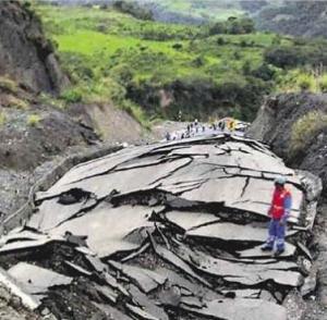
- Earthquake Collapses Road in Amazonas, Peru, Stranding Thousands of Vehicles
May 20, 2010
http://www.livinginperu.com/news-12241-peru-earthquake
- Hundreds of vehicles are stranded in Utcubamba where a large section of the Fernando
Belaunde road was damaged by the 6.4 Richter earthquake. Several sections between the
kilometers 267 and 272 have blocked by landslides, and a 700 metres one has sunk,
preventing the vehicles from passing.
In Tennessee, a massive sinkhole suddenly dropped a stretch of interstate road out of sight. This was
most certainly not a pothole! This shows that traffic was likely flowing over the hole for some time,
before it gave.
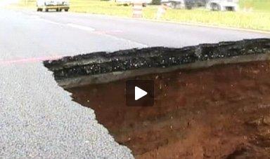
- Sinkhole on I-24 Closes Section of Interstate in Grundy County
May 18, 2010
http://www.wdef.com/news/i_24_sinkhole_road_way_has_collapsed/05/2010
- Traffic heading from Nashville to Chattanooga could be snarled for much of the day. A
giant sinkhole has closed a 17-mile stretch of Interstate 24. The hole is reportedly 25-feet
long, 25-feet wide and 20-feet deep.
The Zetas were asked to comment on the Interstate 24 sinkhole, as this was not an area suffering from
flooding during the recent deluge. What caused this to happen?
ZetaTalk Explanation 5/22/2010: Where sinkholes are routinely blamed on recent heavy rains,
causing a washout, there is more afoot. Run a line from San Diego, the center of the bow formed
by the N American continent lately, and you will arrive at Tennessee. The Utah mine disaster just
east of the Salt Flats was another example of that same bow stress, as it was also on that line. If
a bow is pulled hard enough, it will break, but the break will be along weak points in the wood.
The weak point in the N American continent is the New Madrid fault line and associated fault
lines, which will slip, and slipslide sideways as we have repeatedly explained, with land to the
west of the Mississippi moving SW and land to the east of the Mississippi moving NE. What does
bow stress do to rock and ground in its path? Take a branch and bend it to the point where parts
of the branch start snapping. The compression in the center causes branches to snap outward,
relieving that pressure. Rock layers are no different. When compressed they will shatter away
from the compression point. Ground nearby gets pushed around, as it is not as solid as rock, and
in these matters the hand of Mother Nature does not come round and smooth and distribute the
ground. Pockets or voids remain.
In Russia, a bridge on the Volga River began dancing in strong waves. There were no winds, though
winds were eventually blamed. The human engineers were astonished and had no explanation.
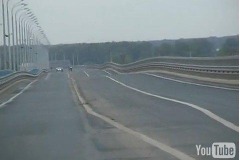
- Wobbly Bridge Shut in Russia
May 21, 2010
http://news.bbc.co.uk/2/hi/europe/10138398.stm
- A 7km (four miles) long bridge over the Volga river in Volgograd, Russia, has been shut
after the structure started to wobble. Strong currents in the river caused by the flow of
water from melting snow upstream apparently loosened one of the bridge's vertical
supports. Officials are deciding whether to reopen the bridge.
Although bridge supports sinking and bridge attachments separating are nothing new, a dancing bridge
certainly is new. The Zetas explain how this is related to the current Earth movements, especially in the
stretch zone.
ZetaTalk Explanation 5/22/2010: No seismic activity would be recorded in a stretch zone, where
rock layers pull apart, and in a halting fashion. River bottom land is sinking, the rock layers
pulling apart which is why it is sinking and has become river bottom land. Rock layers stretched
thing has less support than the thick rock strata in the highlands and mountains. It often takes
very little to start a sway, which builds upon itself. One side of the bridge jerks slightly as rock
layers in the stretch zone pull apart. This is not recorded as a quake because it is not a jolt where
rock slams other rock, but a pulling apart into soft ground, the muck of river bottom land. The
bridge is pulled to one side, and then compensates by a return, which is stronger than the initial
pull because now gravity is involved, and like a pendulum it keeps going. What keeps such a
sway going beyond a jerk and return is a secondary jerk on another part of the bridge, so there
are clash points and ricochet points and a single note on a clarinet a whole orchestra is not
involved, nudging and chasing and striking chords.
Spiral Hoax
Remember the Norway spiral which seemed an almost unbelievable display, surely a painted picture as
it was so perfect. But it was real, captured from several different angles by several different
photographers and witnessed by dozens if not hundreds. Now a similar spiral has appeared in western
Canada.
- TheWeatherSpace Space Stories - Betty Morgan - Contact
May 22, 2010
http://www.theweatherspace.com/news/05-22-2010-UFO-Spiral
- The Norway spiral comes to mind when TheWeatherSpace.com received photographs and
even an amazing video of the event. An object swooped down from the sky and then
returned in a brilliant display across the Western Canada areas. Three different
photographers have given their photos to TheWeatherSpace.com in what looks like
something out of a science fiction movie. We cannot see what would cause this one Earth.
The Norway spiral was said to be caused by a missile launch in the Russian territory. But
what is this?
Once again, as with the Norway spiral, videos and photos from more than one source, but is this a
hoax? This was suspected from the start, because the appearance on the photos and in the videos
differed. And sure enough, the hoaxer came forward.
- Canadian UFO Spiral Hoaxer Comes Forward
May 24, 2010
http://www.theweatherspace.com/news/05-24-2010-Canadian-UFO-Spiral-hoaxer
- What looked like numerous photographs and videos of a ship entering the cosmos was
actually put together by not a team, but one person. Kevin Martin, a Southern California
Weatherman has come forward as the hoaxer to what is likely the biggest hoax ever
created. Martin claims he e-mailed the material to TheWeatherSpace.com in an effort to
test a theory of his out. "Who is more gullible, Americans or Europeans?", asked Martin.
Martin claims that his theory was correct, Europeans have a better handle on reality than
Americans. Upon further investigation it seems like Martin is a master at marketing,
graphics, and even manipulation. TheWeatherSpace.com was fooled.
Was this as claimed, just a test? Per the Zetas, there's more to it.
ZetaTalk Comment 5/29/2010: This crudely done hoax did not fool many, and not for long. The
video looked nothing like the stills. There was no rationale for having a video camcorder or
camera pointing at the sky at that particular moment, held perfectly still and pointing at the sky
in the middle of nowhere. Where were the gasps, the shaking hand, then sudden rush to zoom in.
Other than the hoaxer's stated reason, to test gullibility, what was the reason for the hoax. At a
time when so many signs in the skies are appearing, genuine signs like the Norway spiral and
holographic triangular UFOs, the establishment is searching for ways to confuse the populace.
He was not running a gullibility test, he was delivering a product to employers!
Atlantic Shifting
Volcanoes in Iceland would indicate the Atlantic is pulling apart. Now a distressed tsunami buoy off the
coast of South Carolina showing sudden dept changes and quakes just opposite South Carolina on both
sides of the Atlantic Rift show this to be the case, as noted in a Pole Shift ning discussion. There seems
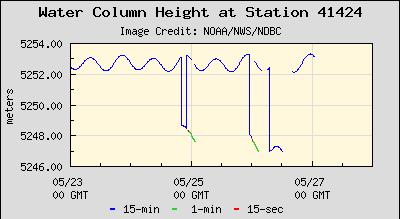
to be a correlation. Buoy 41424 showed erratic wave depths on May 25 to May 27, 2010.
Station 41424 - 370 NM East of Charleston, SC
http://www.ndbc.noaa.gov/
Owned and maintained by National Data Buoy Center
2.6-meter discus buoy
DART II payload
32.930 N 72.497 W (32°55'48" N 72°29'48" W)
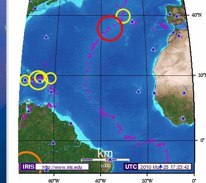
During this same time period there were quakes along the Atlantic Rift, as this IRIS chart for May 25,
2010 shows.
Why would water suddenly drop, during tide action, due to quakes along the Atlantic Rift? As the rift
pulls apart, this creates a void where water can rush in, thus erratic and sudden loss of water pressure
elsewhere. Underwater tow occurs, in these cases, not perceptible on the surface except where a
surface buoy is measuring the distance to the ocean floor. A similar buoy issue came up on April 25,
2010 in the Coral Sea, as detailed in Issue 182 of this newsletter, there indicating a rise in the sea floor
where the Indo-Australian Plate is tipping up at that location.
Pole Shift Survival
An immense database of information on pole shift survival has become available. Check this list of 372
pertinent subjects. Of special note are technical subjects which many survival sites neglect to cover. It is
not just what dried foods to store, but how to refurbish a battery, or build a windmill out of junk, or
build carbon arc lamps that are as bright as sunlight for indoor gardens, or work with hand tools, or
navigate when your compass is worthless. This type of information will provide a survival community
with tasks that will keep them busy and full of hope.
You received this Newsletter because you Subscribed to the ZetaTalk Newsletter service. If undesired, you can quickly
Unsubscribe. You can always access prior Newsletters from the Archives.
|