Pakistan Floods
A series of events seem to indicate that the predicted tilting of the Indo-Australia Plate has started. This
was one of the precursor events allowing the tongue of the Eurasian Plate holding Indonesia to sink, as
presented in the holographic vision received last November, 2009.
The Mediterranean is shown, while Africa rolls somewhat. This opens up the
southern Mediterranean above Algeria such that the Mediterranean floor there is
a crumble, not supported. Then over to India where the western side of India sinks
significantly, the plate tipping sideways a bit, raising eastern India during this
process. Then islands in Indonesia sink, the plate supporting them sinking more
than the surrounding area. Over to S America the Andes are shown doing
mountain building, while some islands in the Caribbean are sinking, their plate
pushed under as S America rolls. Southeastern US is pulled down slightly, while
the land just to the west of the Mississippi drops slightly. As the Atlantic rips open,
this causes water adjustments. First water rushes from elsewhere to fill the void,
then piles up, clashing in the middle, so that a tide rushes toward Europe,
assaulting the lowlands there.
Per the Zetas, during the sinking of the tongue holding Indonesia, the Indo-Australia Plate must tilt.
ZetaTalk Explanation 4/17/2010: We have stated, since the start of ZetaTalk in 1995, that during
the pole shift the eastern side of the Indo-Australian Plate will rise while the western side plunges
under the Himalayas at India. Of course, this is the steady pace as the plates begin to loosen up
and move. In the holographic presentation Nancy attended in November, 2009 she was warned
that additional tipping of the plate will occur. The Indo-Australian Plate will tip sideways so that
Indonesia can plunge under the eastern side of the plate. Islands in Indonesia will be affected by
this plunge, ultimately sinking. Do such adjustments happen all at once, or gradually? Both
occur, but the trend is unmistakable long before a major adjustment occurs.
That said, what evidence is there that the tongue is starting to drop, or that the Indo-Australian Plate is
starting to tilt? First, a series of very deep quakes at the tip of the tongue.
It appears to me that the tenor of the earthquake patterns at the southeastern tip
of the Eurasian plate/Indonesian tongue has dramatically escalated this week with
a new pattern of significantly deeper magnitude 5.x earthquakes along the
southern, southeastern and eastern edges of the Eurasian plate/Indonesian tongue.
Up until this week, I would say that 95% of all the 5.x earthquakes in this region
over the past two years have been well under the 100 km mark in depth. And I
have not seen a cluster like this during the past two years, all over 100 km and all
relatively close to the southeastern tip of the Eurasian plate/Indonesian tongue, in
just one week.
Mag 5.0 - 2010/08/27 - 114.3 km depth - Papua New Guinea
Mag 5.1 - 2010/08/26 - 139.2 km depth - Banda Sea
Mag 5.1 - 2010/08/25 - 233.9 km depth - Halmahera, Indonesia
Map 5.3 - 2010/08/25 - 173.7 km depth - Sulawesi, Indonesia
Mag 5.0 - 2010/08/24 - 593.8 km depth - Mindanao, Philippines
Mag 5.0 - 2010/08/24 - 176.2 km depth - Flores Region, Indonesia
Mag 5.5 - 2010/08/23 - 121.6 km depth - Guam Region
In step with the deep quake activity, a Sumatra volcano that had not erupted in 400 years became
active. Sumatra is on the edge of the tongue.
- Indonesian Volcano on Island of Sumatra Erupts for First Time in 400 Years
August 28, 2010
http://www.bloomberg.com/news/2010-08-29/indonesian-volcano
- The Sinabung Volcano on Indonesia's Sumatra island erupted this morning for the first
time in 400 years, spewing ash and volcanic materials and prompting the evacuation of
surrounding areas.
All this certainly indicates activity in deep rock at the end of the tongue, but what about the other side of
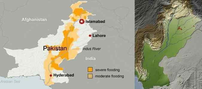
the Indo-Australia Plate? Does all that flooding in Pakistan of late have something to do with a sinking
edge? The Indus River is on the edge of the Indo-Australia Plate where it is being pushed under the
Himalayas. Note the escalating concern as the magnitude of the flooding surpasses expectations.
- 2.5m People Affected by Pakistan floods
http://www.bbc.co.uk/news/world-south-asia-10834414
August 2, 2010
- Yet more rain is forecast
-
- Floods Affect 20m People - Pakistan PM Gilani
August 14, 2010
http://www.bbc.co.uk/news/world-south-asia-10973725
- Flood levels are expected to surge even higher along parts of the already dangerously
swollen Indus river, with disaster officials saying "major peaks" were expected next week
in Punjab and Sindh provinces.
-
- UN Chief Ban Ki-Moon: Pakistan Floods Are Worst Disaster I've Ever Seen
August 15 2010
http://www.huffingtonpost.com/2010/08/15/pakistan-floods-ban-ki-moon_n_682649.html
- U.N. Secretary-General Ban Ki-moon said Sunday he has never seen anything like the
flood disaster in Pakistan after surveying the devastation and urged foreign donors to
speed up assistance to the 20 million people affected.
-
- Struggle for Food as Pakistan Floods Worsen
August 24, 2010
http://www.abc.net.au/news/stories/2010/08/24/2991318.htm?site=news
- From the air it looks like a country without any dry land. Thousands of people are packed
onto levy banks and tiny strips of road that sit just above the water line.
There is no question that Pakistan had heavy rain, but is all the flooding due to rain, or is part of the
problem a drop in sea level. Per the Zetas, the Indo-Australian Plate has started to tilt!
ZetaTalk Explanation 9/4/2010: The Indus River is one of the points on the Indian sub-continent
that is being pushed under the Himalayas range, as a close look at where the mountain building
along the northern edge of the Indo-Australian Plate occurs. We have pointed out that the
mountains in the interior of India seem to disappear as one approaches the Himalayas, and that
this is because it is there that the plate is being pushed down. We have predicted that as the
tongue of the Eurasian Plate holding Indonesia is pushed under the eastern edge of the
Indo-Australian Plate that this edge will lift, tilting the Indo-Australian Plate down on the
western edge. This would first be noticed on land, especially land subject to being flooded, as
such a change under the sea would escape notice unless a tsunami buoy sounded an alarm. What
should be noted is that the flooding, ostensibly from rains, kept getting worse than anticipated
from the rains alone. What should be watched is how well the flood waters drain, and whether a
drop in elevation is noted along the Indus River and its outlet into the Indian Ocean. The Earth
changes we have predicted for this region have begun!
Of course, the clams offshore from Karachi knew something was up when they started trying to leave
their home and climbing up the beach last July! And on the other side of the Indo-Australian Plate,
mollusks were reacting in a similar manner.
VIDEO: http://www.youtube.com/watch?v=JrLMdnWQsWA
Question: A video was posted on this site showing huge numbers of clams
beached in Karachi, Pakistan. Similar but less dramatic observations involving
the beaching of bivalve mollusks has been seen in New Zealand in recent weeks. Is
this a sign of seismic/magnetic anomalies being sensed by sea life?
ZetaTalk Answer 7/24/2010: Just as pets leave home in an attempt to get away from an areas
that is having electromagnetic screech prior to an earthquake, forsaking food and shelter and
comfort, creatures in nature attempt to escape. Electromagnetic screech, as earthquake
sensitives can report, create muscular and skeletal aches and pains, ear aches, head aches, and
nausea. Both electrons and magnetons are involved in electromagnetic particle flows, as the
nervous system of both man and beast operates by chemical electricity of sorts. To be in such a
locale is painful, and thus the creatures flee in any direction where the pain is relieved. Man
represses his awareness of this pain, or attributes it to stress, fatigue, the weather, or perhaps a
cold of flu. Animals are not trying to fit into a social scheme, and thus view the situation in a
more simplistic manner. They don't bother to pack up and make arrangements, they just go.
N American Fracture
The Zetas explained the underlying reason for the devastation to be caused by the New Madrid Fault
adjustment as a diagonal tearing of the N American continent. This is caused, at base, by the N
American Plate being unable to roll, as it has a flat top on the boundary it shares with the great Eurasian
Plant.
ZetaTalk Explanation 2/10/2006: The giant plates of N America and Eurasia are locked against
each other, unable to rotate against each other due to their shape. This creates a diagonal stress
on the N American continent where New England is pulled to the east while Mexico is pulled to
the West. The New Madrid is put under slip-slide stress where one half, east of the Mississippi,
will move toward the NE while the other, west of the Mississippi, moves toward the SW. The
stress on the N American plate will resolve by ripping. Ripping the St. Lawrence Seaway open.
What causes the N American continent to rip at the Seaway? And how would this tear proceed as the
hour of the pole shift approaches? This question was asked recently on the weekly Q&A taking place
on the Pole Shift blog. The Zeta answer addressed the underlying rock strata, which shows quite clearly
why the tear of the Seaway occurred as it did.
Question: I did a search on ZetaTalk about the splitting of the St. Lawrence
Seaway and its consequences. I am having a hard time picturing how this split will
play out. There will be three splits? One north-south along the Mississippi, one
east-west to Duluth, and one across Wisconsin to Minneapolis and onward to the
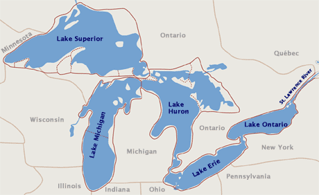
Black Hills? How will this split affect the geography in Wisconsin and around
Lake Superior? Lake Superior is approximately 183' above sea level and averages
close to 500' deep (deepest point is about 1,330'). Will the lake area become
larger? Will land along the southern shoreline be lost, or will land actually gain
height due to the lowering of the lake level resulting from the seaway split? Can
you elaborate on the east-west seaway split effects and the topographical changes
we can expect to occur in the North Central US because of the Seaway split?
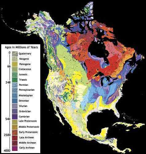
ZetaTalk Explanation 9/4/2010: One can see from a map of the underlying rock strata that the
Seaway began forming due to a weak connection between rock strata of different formation
types. This is similar to the sea in an article of clothing. Not visible necessarily from outside the
garment, but a weak point and liable to rip first or most readily when the seam starts to unravel.
The Seaway in essence runs along this boundary, except for Lake Erie which is south of the
boundary. There is, thus, the potential for the Seaway to break through between Lake Huron and
Lake Ontario, a path already forming as the geology of eastern Lake Huron shows. Such a
breach would run well north of Toronto, and would create a crevasse rather than sink land, so in
the scheme of things would not be that traumatic for the residents in the area. We have
mentioned that Niagara Fall would widen, the Seaway finding new routes in the shattered rock,
and thus the falls essentially gone.
The locks between the Great Lakes will be shattered or broken long before the hour of the pole
shift, so adjustments in lake water height will have started. The Seaway split has chosen to run
through Duluth, MN an on west from there rather than through Wisconsin where the bond
between and the various rock stratas is of a stronger nature. The Seaway can be expected to
proceed, thus, beyond Duluth, creating a crevasse again through upper Minnesota, with
sympathetic rumpling of lands all the way to the Black Hills. Wisconsin has been splitting along
rock strata too, creating the Green Bay peninsula at the juncture of Green Bay and the body of
Wisconsin, as the peninsula has a different rock type. This split will continue and widen, creating
a bay all the way to Madison and potentially through to the upper Mississippi, although this
breach will certainly occur at Chicago through the canals dug under this city.
The underlying rock strata also shows a break or border between rock types where the lower elevation
along the Mississippi will occur. Per the Zetas, the significant widening of the Mississippi will occur to
the west of the Mississippi only below the Illinois border, and to the east of the Mississippi only in
counties in the NW of the state of Mississippi. All this area is currently lowland, and of a consistent rock
type.
ZetaTalk Explanation 9/4/2010: As can be seen by an analysis of the rock strata to the east and
west of the Mississippi, the Mississippi is following the curve of solid rock just to the east. The
potential for a greatly widened Mississippi occurs south of the Illinois border. To the south of this
point the sea level elevation is lower and the rock strata is of a different nature than that above
or to the east of this point. This is where the Mississippi will spread, to the west between the
Illinois border and the Mississippi delta. We estimate the Mississippi will widen by 50 miles, give
or take depending on its meandering and the stability of the rock or soil in any given location.
Lowlands in Bolivar and Washington counties of Mississippi state are also vunerable to this
flooding.
Likewise, specifics have recently been given on the exact sequence of events to occur during the New
Madrid adjustments.
ZetaTalk Explanation 8/28/2010: Indeed, tearing of the St. Lawrence Seaway will occur during
the New Madrid adjustment. We have warned that quakes on the West Coast, or the Seaway, or
in the New Madrid region will occur before the major quake in the New Madrid region we have
referred to as the adjustment on a 7 of 10 level. There will be quakes in these areas, magnitude
4-7, which should not be considered the New Madrid adjustment of which we speak. When the
tension in the N American continent starts to force major tearing of rock strata, so that the
changes we have described can take place, this will not be all at once, simultaneously. We have
described a series of large quakes, with one major one stemming from the New Madrid area that
will be called a magnitude 9 but in truth will be larger. It is this quake that will set in motion
adjustments elsewhere.
Mexico will lurch to the west as this major quake occurs, with a settling of land to the west of the
Mississippi almost instantly afterwards. The Mississippi will seem to have widened, and those to
the west will see a new view as they look east, as their land will have shifted to the southwest as
well as dropped. Because the lurch of Mexico to the west actually intensifies the bowing of the N
American continent, the Seaway tears open. This is actually various adjustments at weak points
along the Seaway rather than the tearing apart into a larger inland bay that occurs during the
pole shift itself. Niagara Falls will remain, but some of the inland locks will break. When the
upper Mississippi region finds the land to its west slipping down and to the southwest, those parts
north which were formerly firmly attached find they can spring northward, as the pressure from
the bow had been inclining them to do. This allows the edge of the rip, at Duluth, MN, to tear
further inland, with consequent rumpling in S Dakota and minor shifting of ground in all parts in
between.
All of this occurs, of course, before the pole shift itself!
Red Lakes
Iran's Lake Urmia has recently turned red, as result of an algae bloom.
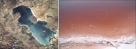
- Photos: Lake Urmia Turns Red
August 18, 2010
http://www.payvand.com/news/10/aug/1181.html
- The surface of the salt water lake recently turned red due to a phenomenon known as red
tide. Declining rainfall, climate change, and rising temperatures are accelerating the
evaporation process at the lake. Environmentalist Masoud Baqerzadeh-Karimi has
dismissed the claim that wastewater is the cause of the rare red tide phenomenon, adding
that if that were the case, the lake water would have turned red many years ago.
Such blooms have prompted speculation that the Burgundy Blood algae, Oscillatoria rubescens, is
responsible for the reports of rivers and ponds turning blood red during the time of Moses and the
Jewish Exodus.
- Biblical Plagues Really Happened say Scientists
March 27, 2010
http://www.telegraph.co.uk/science/science-news/7530678/Biblical-plagues
- The rising temperatures could have caused the river Nile to dry up, turning the fast flowing
river that was Egypt's lifeline into a slow moving and muddy watercourse. These
conditions would have been perfect for the arrival of the first plague, which in the Bible is
described as the Nile turning to blood. This description could have been the result of a
toxic fresh water algae. Known as Burgundy Blood algae or Oscillatoria rubescens, is
known to have existed 3,000 years ago and still causes similar effects today.
Per the Zetas, there will be no confusion, as when the red dust from the tail of Planet X starts to arrive in
earnest, it will be during the last weeks and will be unmistakable.
Things which must shortly come to pass;
And I beheld when he had opened the sixth seal, and, lo, there was a great
earthquake; and the sun became black as sackcloth of hair, and the moon became
as blood;
And the kinds of the earth, and the great men, and the rich men, and the chief
captains, and the mighty men, and every bondman, and every free man, hid
themselves in the dens and in the rocks of the mountains;
And there appeared another wonder in heaven; and behold a great red dragon,
having seven heads and ten horns, and seven crowns upon his heads.
And the third angel poured out his vial upon the rivers and fountains of waters,
and they became blood.
Bible, Book of Revelations
ZetaTalk Prediction 1/15/1996: A second countdown sign is a fine red dust, unmistakable as it
cannot be confused with any other natural occurrence. Ponds and rivers turn red, the blood color
mentioned in the Bible's book of Revelations, with this iron ore dust giving the water a brackish
taste. This countdown sign comes almost in step with the rapid slowing in rotation, This occurs a
day or so before rotation stops.
You received this Newsletter because you Subscribed to the ZetaTalk Newsletter service. If undesired, you can quickly
Unsubscribe. You can always access prior Newsletters from the Archives.
|