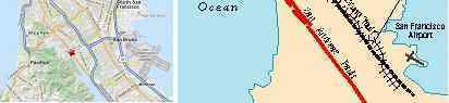
Fault Line Explosions
On September 9, 2010 a gas distribution line almost atop the San Andreas in San Bruno on the San
Francisco peninsula exploded, starting a massive conflagration.
- Crews Search Ash-Covered Homes after Blast Kills 4
September 11, 2010
http://news.yahoo.com/s/ap/20100911/ap_on_bi_ge/us_large_explosion
- Officials were trying to determine what led up to the conflagration that killed at least four
people, injured dozens of others and raised questions about the safety of similar lines that
crisscross towns across America. The utility that operates the 30-inch diameter line said it
was trying to find out what caused the steel gas pipe to rupture and ignite. Federal pipeline
safety inspectors were also on the scene. Transmission lines like the one that burst in San
Bruno deliver natural gas from its source to distribution lines, which then carry it into
neighborhoods before branching off into homes.
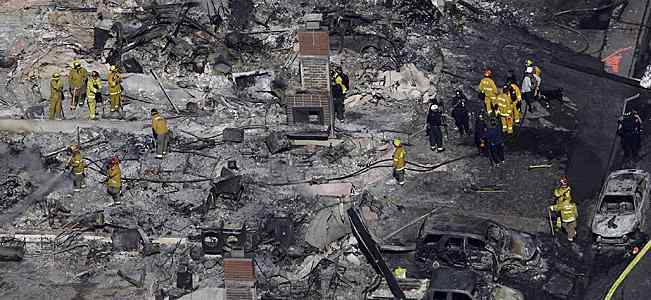
- San Bruno Fire Levels Neighborhood - Gas Explosion
September 10, 2010
http://www.sfgate.com/cgi-bin/article.cgi?
- The wind-whipped blaze leaped from structure to structure in the neighborhood near
Skyline Boulevard and Sneath Lane, west of Interstate 280.
Per the Zetas, aging gas lines and fault lines do not mix, especially because rock can fracture to either
side of the fault line.
ZetaTalk Comment 9/18/2010: Fault lines, when adjusting, do not just rip apart one day during a
dramatic earthquake. They most often creep. Laying gas lines along or across a fault line is
asking for an accident of this sort. Fault lines are also seldom so clearly delineated that one can
go a mile in this or that direction and avoid their action. Where a slip-slide fault such as the San
Andreas will often leave a clear line on the surface, this is only the surface action, not what
occurs in the rock layers on either side which can fracture for a long way to either side during
any movement. The gas company, or the age of the pipes, will be faulted but in truth the finger
should be pointed in many directions. The public, who insist on living at such a scenic spot are to
blame. Officials, who zoned for housing are to blame. The public utility company, for allowing
gas lines in the area, are to blame. But this will change nothing, while man continues to live on
the San Andreas, even as it awakens.
Yes, the San Andreas has awakened, and the S American continent has begun to roll, as predicted in
the holographic presentation I was privy to last November, 2009. This was presented in Issue 169 of
this newsletter.
Over to S America the Andes are shown doing mountain building, while some
islands in the Caribbean are sinking, their plate pushed under as S America rolls.
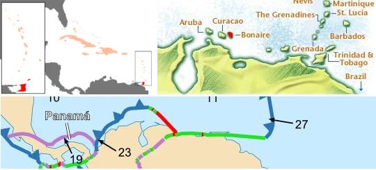
If the San Bruno explosion on the San Andreas occurred on September 8, 2010 the Bonaire explosion
where the S American and Caribbean plates meet occurred on September 2, 2010, for similar reasons.
S America is grinding over the Caribbean Plate, pushing the islands just to the north of S America down
during this process.
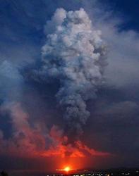
- Another Oil Disaster, This Time in the Caribbean
September 11, 2010
http://www.onearth.org/onearth-blog/huge-oil-fire-rages-on-caribbean-island
- A still-smoldering fire that raged out of control for two days at an oil storage facility on
the Caribbean island of Bonaire has left residents shaken. And with echos of the BP
Deepwater Horizon, they wonder how such a disaster, consuming 20,000 barrels of oil
products at a Venezuelan-owned terminal called BOPEC, could continue unabated for so
long.
Bonaire is along the border between the massive S American Plate, which is rolling over the Caribbean
Plate at this location. This is likewise true of Trinidad and Tobago, the site of another oil rig explosions
caused by one of the platform legs filling unexpectedly with water. The Aban Pearl sank on May 13,
2010.
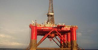
- Venezuelan Gas Rig Sinks
May 13, 2010
http://www.theglobeandmail.com/report-on-business/venezuelan-gas-rig-sinks/article1567300/
- The accident appeared to have been caused by a sudden surge of water entering one of the
submarine rafts that the platform's legs float on, and a submersible robot was being used
to investigate further. The site near Trinidad and Tobago.
Note that both these locations, Bonaire and Trinidad and Tobago, are along the fault lines.
7 Steps
Those who first learn of the pending pole shift and the presence of Planet X in the inner solar system are
often at a loss on where to start. They know global catastrophes will happen, and preparations should
be made, but where to start? The ZetaTalk website is vast. Recently, in anticipation of an uptick in Earth
changes with many newcomers to the subject suddenly becoming aware for the first time, the Zetas
provided some advice.
ZetaTalk Advice 9/11/2010: Step 1 is to research your location in the Safe Locations information
on the ZetaTalk website. In this you should examine not only your country, your state or
province, or your city but also any nearby. Your specific town may not be covered but the whole
river valley may be predicted to flood and to flood permanently. This would be a clue that your
specific town will be likewise affected. We cannot and have not addressed every spot on Earth,
due to time and energy constraints.
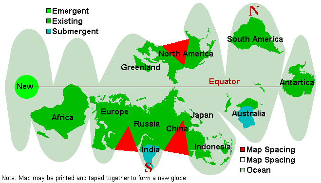
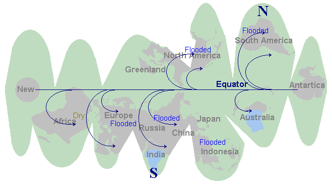
Step 2 is to research your location from the standpoint of the climate that will exist after the pole
shift. This is quickly ascertained by looking at the New Geology map. This is a free map which
can be cut out and taped together and will give a general idea of the latitude to expect. If your
chosen location is where one of the new poles will be, this is a clue that you need to rethink or
plan a migration route. This is likewise the case if your chosen location will be on land that will
sink below the waves entirely, such as India or western Australia.
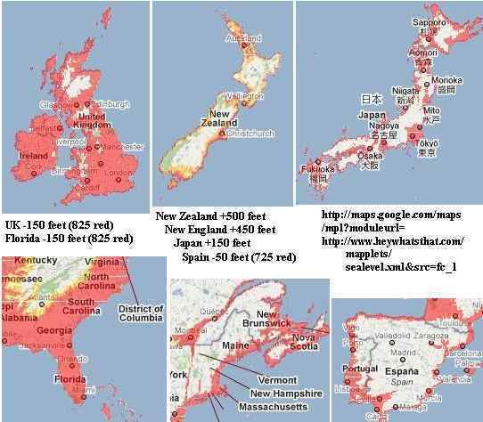
ZetaTalk Advice 9/11/2010: Step 3 is to research your elevation above sea level. A handy and
free tool is Google Earth which can be downloaded into a PC and will show the exact elevation
of any spot the cursor passes over. Google Maps is a modified version that allows a color coded
map based on elevation. Our advice to be 100 miles from a coastline and 200 feet above sea level
to avoid the coastal tidal waves during the pole shift should be applied. You can determine your
current elevation and whether your location will be 675 feet above sea level where the water will
rise within 2 years after the pole shift. A rough guide in this matter is the map Nancy created.
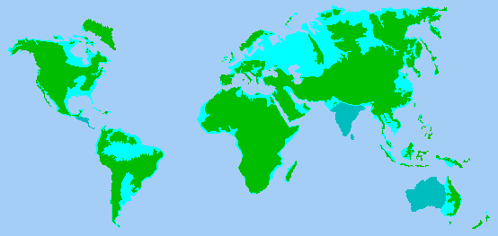
ZetaTalk Advice 9/11/2010: Step 4 is to determine if you are in one of those regions which will
rise or fall. India and western Australia will be below the waves as of the time of the pole shift,
and being pushed down before the pole shift. Japan gains 150 feet, New Zealand gains 500 feet
and eastern Australia benefits also, Spain loses 50 feet, western UK loses 150 feet, New England
gains 450 feet due to the Seaway rip, Florida loses 150 feet, and Vancouver Island gains 100
feet.
ZetaTalk Advice 9/11/2010: Step 5 is to research the effect of swollen rivers which will likely be
in a backwash during the pole shift. We have stated that all rivers will be over their banks, so the
worst possible scenario should be assumed. What will happen if the river cannot drain? Despite
having a good sea level elevation, any land that does not have an advantage of being at least
200 feet in elevation over a major river bottom in the vicinity is likely to be flooded. A backwash
from the main river in your vicinity should be assumed, so that creeks will not drain, for instance.
Water on the move tears and bites and scours, and will undercut the soil under buildings so they
will tilt and tumble. Being on solid rock that will not melt in this scenario is advised. Tidal bore
along cliffs facing the ocean can likewise have water climbing up, or funneled up by ravines
which will direct water all the way to Guadalajara from the Pacific, for example. Think this
through, for your location, and be on the safe side.
Step 6 is to examine your volcanic or geographic risk due to mountain building. We have advised
a 100 mile radius from all volcanoes that have been active within the last 10,000 years, and that
Yellowstone will not become a super volcano. You can determine if the new westerly winds will
blow volcanic ash in your direction. Consider that what was formerly north will now be west or
east. Fire storms, though extremely rare, almost always occur near erupting volcanoes during
the hour of the pole shift. We have advised that if in areas subject to mountain building that old
rock not shattered is a good guide to what will survive, and newly fractured rock is a clue that
more of the same might be expected. Older mountains as the Alps and Appalachians are
considered safe, where the Sierras and Andes are building.
ZetaTalk Advice 9/11/2010: Step 7 is to ascertain if you need a migration route. It is possible to
survive the pole shift by avoiding tidal waves and staying outside of structures that will crush
you, but to be in a position to be flooded within 2 years after the pole shift. Siberia is a case in
point. Here the land is so low in elevation that vast swaths of land will be flooded, and survivors
must plan to migrate on foot or via boat. Survivors near the new N Pole off the Bulge of Brazil
might consider migrating toward the Andes and their familiar tropical warmth. Such migration,
and your target location, can be plotted. Migration routes can be expected to be crowded, so
should be avoided as a location for survival camps in general.
Rattled Wobble
The Zetas reported in July that the wobble had changed from its slow steady roll into a Figure 8 daily
into what they called a rattled wobble. Recently someone noted that the live seismographs seemed to
have global shuddering on more than the twice-daily-and-12-hour-apart shudder, as had been the norm
since 2003, but appeared often to be on an 18 hour schedule. I did an analysis.
- The twice a day shuddering that used to occur during the wobble would be just ahead of the 0:00 and
12:00 UTC points, at what we called the Face and Dark sides. This was when the Atlantic Rift was
either facing Planet X at 12:00 UTC or in opposition on the dark side of Earth at 0:00 UTC.
Presumably this pattern is still there. An analysis of the last 30 days earthquakes above magnitude 6
shows this pattern still active.
- 2 (between 21:30-23 UTC) 14% (Mariana Trench)
3 (between 11-12 UTC) 21% Ecuador, Aleutians, Vanuatu
-
- But an analysis of the live seismograph for September 10, 2010 shows a slight shudder also at 3, 8, and
17 UTC. Even when the live seismographs were almost dead quiet on September 11, 2010 that pattern
still showed. Quakes above magnitude 6 also line up with these times.
- 3 (between 2 - 3:30 UTC) 21% Vanuatu, Reunion, Mexico
3 (between 7:30 - 9 UTC) 21% Mariana, Tongo, Chile
3 (between 16:30 - 18 UTC) 21% Fiji, Solomons, New Zealand
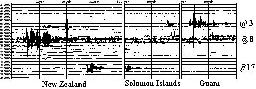
ZetaTalk Explanation 9/11/2010: The rattling wobble has formed a pattern of sorts, though just
as soon as this pattern is understood or recognized, it is likely to change. As Nancy has pointed
out, the twice-a-day shudder - when the Atlantic Rift is facing Planet X at 12 UTC and later at 0
UTC when it is in opposition on the other side of the globe - is still present. Since the Atlantic Rift
runs from Iceland to South Africa, this involves a tug that affects the entire globe. As Nancy's
earthquake analysis shows, the scope of quakes is broad during those times, running pole to pole,
and tends to hit those points which are already vulnerable to plate movement - the S American
roll, the folding Pacific, and the diagonal pull on the N American continent.
The daily Figure 8 roll caused by the N Pole of Earth being pushed away when it comes over the
horizon continues. This occurs when Planet X is facing the central Pacific at 18 UTC and as
would be expected hammers at the brake point near the Solomon Islands. At 3 UTC a similar
point is reached when the N Pole of Earth is hidden behind the horizon so the globe can bounce
back. Significantly, a quake occurred in the Reunion Islands off the eastern coast of Africa in
Nancy's analysis during this time.
But in addition to the Atlantic Rift tug and the N Pole push and rebound there is also stress on
the globe from Earth glancing off the magnetic field of Planet X. This is not the temporary tug or
the back and forth shove but a sudden flip to the side into a temporary lean to the left or
opposition. As is known, there is a magnetic anomaly just to the west of South Africa, which acts
almost like a second S Pole for Earth and is positioned on the other side of the Earth at the same
latitude from the Earth's magnetic S Pole. The N Pole of Planet X grabs this anomaly, as it is a
type of S Pole, thus lurching plates nearby. Significantly, in Nancy's analysis, Chile had a quake
during this 8 UTC time period.
You received this Newsletter because you Subscribed to the ZetaTalk Newsletter service. If undesired, you can quickly
Unsubscribe. You can always access prior Newsletters from the Archives.
|