Taiwan Media
The Monster Sun, a version of the Second Sun, has been making an appearance lately. Per the Zetas, this persona appears
huge because light rays that are bending outward from Planet X and its massive dust cloud are bent back toward the viewer.
The Monster Sun was frequently seen in late 2003, when Planet X had just moved into the inner solar system.
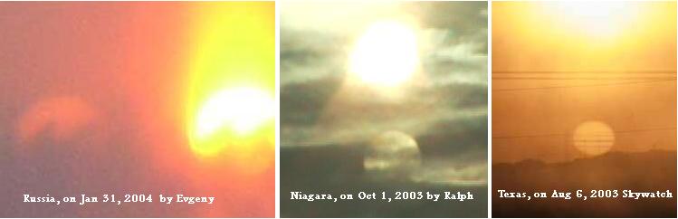
ZetaTalk Explanation 11/16/2003: The Monster Sun is light that has moved in all directions, bent back toward Earth
by the gravity trap it represents, from a broad area, so when arriving at the viewer represents a broad orb. The
Monster, or Mega-Monster as Nancy likes to call it at times, has also been seen recently by naked eye, astonishing
the viewers. This is of course not the actual size of Planet X, and because the light forming the Monster is so readily
disbursed, it is a dim persona, always.
The appearance of a Monster Sun requires a particular angle for sunlight bounce, and the position of Planet X has apparently
afforded that angle again! A video of a Monster Sun capture appeared on March 3, 2011 on Taiwanese TV.

VIDEO: Taiwan http://www.youtube.com/watch?v=MJkurPs9smA
I'm fluent in Chinese Mandarin. They are talking about people on the Internet who talk about and
make videos on the Planet X/Nibiru topic. Some people believe the world will end. Internet bloggers
believe the world will be ending, while others believe it could mean aliens may invade the planet.
Whether this is authentic or not, some believe it could have been altered, while others believe it could
be a 2nd sun or another celestial body.
The weather expert in Taiwan explained that this is just a "phantom sun phenomenon", due to the
reflection of the sun from the icy clouds. It is a rare occurrence, and this event is even more rare as
the reflection is so close to the original sun. He assured the public that there is nothing to worry
about, for the world is not be coming to an end unlike what Internet bloggers have been discussing
about.
Per the Zetas, the Taiwan reaction may be a model for future leaks about the presence of Planet X.
ZetaTalk Comment 3/5/2011: We are often asked how the cover-up will break, as it is at present a standoff, at least
by the great powers who dominate the scene. The US, having been at the helm of all decisions over revealing either
the alien presence or the approach of Planet X, is most reluctant for the cover-up to break. There is intense
reluctance by so many participants, that any move to reveal the truth to the public is sabotaged. Assassinations
occur, and increasingly savage threats are made. Outside of the US, the urge to tell the truth has resulted in many
countries finding a way to have the discussion before their public.
This incident in Taiwan is one such incident. This is a monster sun, one of many personas that Planet X presents.
Taiwan presented the evidence, stated what many on the Internet are saying, then gave a reassurance and an official
explanation for the phenomena under discussion. They have, in short order, just informed the public that Planet X,
aka Nibiru, is indeed in the skies, near the Sun, and the prophesied cataclysms are not without basis. They have even
given the public search engine words to use in order to hone in on the subject, and learn more! Who in the public
would believe the excuse given, that the Sun has been reflected off a cloud bank! Those giving the excuse cannot
come up with an example, ever, from the past!
Because the media presented this as a debate, with both sides commenting, they cannot be accused of breaking the
cover-up. S Korean TV did something similar recently. The final product presented Nancy's evidence, then
juxtaposition NASA refuting it all, and then let Nancy have the final word. NASA's arguments were then seen for
what they are - inadequate. Will this media technique become popular, and used elsewhere? This and other such
techniques are likely to be used, as the evidence becomes so much more compelling, the Earth changes in the news,
and the public demanding an explanation.
Signs in the Sky
Planet X Moon Swirls have also been making dramatic appearances. Since the massive tail of Planet X, which includes the
Moon Swirls, has been turning increasingly toward the Earth, these hose like swirls are funneling light down their length like
mega flashlights - closer to the Earth, and thus, the light is brighter. One such capture was in Manchester, UK on March 3,
2011 with additional captures on the days following. Planet X is normally seen around the 4-5 o'clock position from the
northern hemisphere, so this is a suspected Moon Swirl capture. Moon Swirl orbs can be quite bright, brighter than the
corpus of Planet X itself.
VIDEO: http://www.youtube.com/watch?v=ChE8-LbZ3jg

On March 5, 2011 a Moon Swirl was captured on film in Puerto Rico. Amazingly, the swirl was reflected and seen naked
eye not only in a swimming pool at 9:00 am but on the windshield of a car at 11:45 am - precisely in the same position in both
reflections. This is not a lens flare, as no lens was involved in the water and windshield, but a real orb in the sky displayed on
both surfaces!
VIDEO: 9:00 am http://www.youtube.com/watch?v=1297-dElXlA&feature=related
VIDEO: 11:45 am http://www.youtube.com/watch?v=fzzpe5J9j6s&feature

Are we also seeing the corpus of Planet X, the planet itself, shrouded in red dust? During this period of increased visibility,
the corpus itself was also captured on film in Perth, Australia on March 7, 2011. Note for the Southern Hemisphere the view
of the Sun is reversed from what the view would be in the Northern Hemisphere. For the Northern Hemisphere Planet X is
seen at about the 4-5 o'clock position, but for the Southern Hemisphere, it is at the 10-11 o'clock position. And there it is,
right next to the pink flare, a reddish orb!

Then on March 6, 2011 there were dramatic Moon Swirl captures from New Zealand, both in photos and on a video. The
video demonstrates that the orb is not a flare, as it does not move about when the camera angle is changed, as the flares do.
A hint of a Monster Sun can also be seen in one of the photos. The orb was also seen naked eye.
VIDEO: http://api.ning.com/files/XLMGemAl1oxdMbEZ9cpARfMoJQ*

Yesterday I managed to photograph what I think was Planet X, you all asked for video and I got
video! Also we can see the planet with the naked eye, while wearing 3 pair's sunglasses. While
watching the video take note of the sun flares, moving around, also take note the object is not
moving and stays under the sun, while the camera is moved around the sky. Notice the light beam,
coming down to earth in the same way a ray of sunlight comes down to earth.
Cracks and Crevases
Just this past week, cracks and crevasses appeared in Peru, Pakistan, and the Philippines! Plates are on the move! The crack
in Peru went for a long distance, though did not separate into a wide crevasse. Nevertheless, this alarmed those in Ica. Ica,
Peru is being driven over the Nazca Plate, and matters will get worse as the S American roll progresses.
ZetaTalk Prediction 10/2010: Along the Andes, these quakes will be in the range of a magnitude 8-9, but lesser
elsewhere. In that the Andes will rise, riding over the Nazca Plate to the west, no significant tsunami will be
produced along the west coast of S America. All major cities in the mountain building areas will experience these
great quakes - Santiago, La Paz, Lima, Qinto, and Bogota.
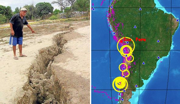
- Peru: Ica Alarm Ground for Strange Cracks.
February 4, 2011
http://www.peru.com/noticias/fotos20110204/138266/Alarma-en-Ica
- Alarm in Ica by strange and huge cracks in the earth
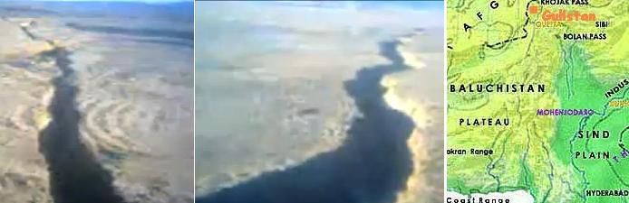
In Pakistan a very long crevasse opened up in Seagi Gulistan, so long it takes 6 minutes to walk from end to end. This region
of Pakistan is on the border of the plate holding India and Australia, the Indo-Australian Plate. The Indus River Valley has
lost 10 feet in elevation at the start of the 7 of 10 scenarios, which began with the tipping of the Indo-Australian Plate. The
video was posted on March 7, 2011.
ZetaTalk Prediction 9/4/2010: The Indus River is one of the points on the Indian sub-continent that is being pushed
under the Himalayas range, as a close look at where the mountain building along the northern edge of the
Indo-Australian Plate occurs shows. We have predicted that as the tongue of the Eurasian Plate holding Indonesia is
pushed under the eastern edge of the Indo-Australian Plate that this edge will lift, tilting the Indo-Australian Plate
down on the western edge.
VIDEO: http://www.youtube.com/watch?v=Eg0pMzqoe7c
And turning the globe once again, to Bohol in the Philippines, we find yet another crack, this one likewise appearing on
March 7, 2011. The Philippines are sinking, as they are housed on the plate tongue holding Indonesia, and are also rising
slightly whenever the Philippine Plate pushes under them. Per the Zetas, a very precarious position.
ZetaTalk Prediction 2/26/2011: The issue is not how fault lines within the Philippine islands will inch in this direction
or that, but what will happen to the entire island structure during the massive plate adjustments pending. The
Philippine Islands ride on the edge of the Eurasian Plate tongue holding Indonesia. As such they are subject to being
crushed from the east and pushed down, simultaneously. As has been noted during the sinking of the tongue, the
sinking has not been uniform. The plate tongue is folding like an accordion, so that portions sink, other portions rise,
and all are buckling and crumbling. There is pressure from the east, so that the islands will buckle, weak points
either rising up or dropping, suddenly, creating a jumble.
VIDEO: http://www.youtube.com/watch?v=vUUfQrNih1A&feature=player_embedded

- Land Cracks Alarm Residents in Sierra-Bullones, Bohol, Philippines
March 7, 2011
http://ph.miloriano.com/youtube-video-onland-cracks-alarm-residents-in-sierra
- The continued land movement causing huge cracks in a barangay in this municipality alarmed residents as
authorities advised them to evacuate to safer grounds especially during uninterrupted rains. Edgar Uporto
from the Mines and Geosciences Bureau (MGB) regional offices based in Cebu said the earth movement is
caused by a constant flow of water under the ground which can be minimized if the flow of water can be
diverted to a more stable area.
And in the heart of the current plate movement in Java, matters are worse. On March 9, 2011 Central Java, on the sinking
edge of the plate tongue holding Indonesia, another crevasse was reported in the village of Gedawang. The crack is 500
meters long, and on a road repaired just the month before for the same condition! Java is crumbling. In East Java on the
border with Timur, crumbling land is cracking homes apart.
VIDEO: http://www.metrotvnews.com/read/newsvideo/2011/02/03/121779/Jalan
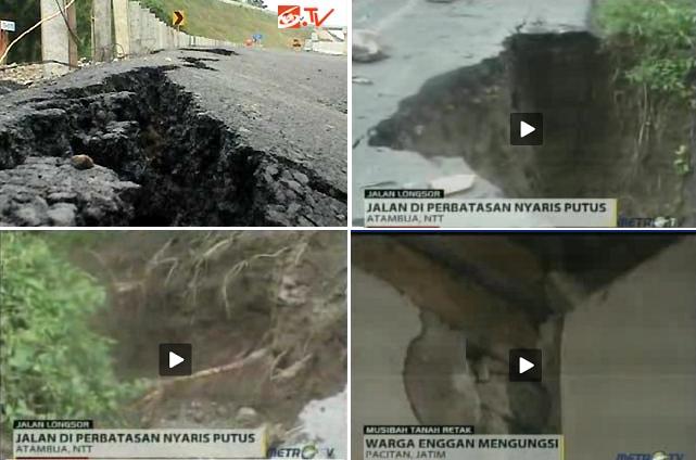
- Semarang-Solo Toll Road Sinkhole
March 9, 2011
http://berita.liputan6.com/daerah/201103/323435/Jalan_Tol_Semarang_Solo_Ambles
- The road ambles on joint road-Susukan Gedawang, precisely in the Village Gedawang, District Banyumanik,
Semarang, Central Java. This is the second time after the completion of the highway sinkhole repair
construction last February. As a result of subsidence, the link that is not passed this vehicle crack along 500
meters with a depth of 60 centimeters and 70 centimeters wide. To prevent a wider rift, installed concrete piles
in 150 points with a depth of 30 meters to stabilize the condition of the land.
-
- Roads Indonesia-Timor Leste Border Closed Avalanche
February 3, 2011
http://www.metrotvnews.com/read/newsvideo/2011/02/03/121779/Jalan-Perbatasan
- A number of roads to the border of Indonesia-Timor Leste, in Atambua, East Nusa Tenggara, on Wednesday
(2 / 2). breaking point. One side of the road ambrol into the abyss as deep as 30 meters.
-
- Hundreds of Houses Damaged
March 3, 2011
http://www.metrotvnews.com/read/newsvideo/2011/03/03/123496/Tanah
- Land moved back there in Hamlet Krajan, Ngumbul Village, District Tulakan, Pacitan, East Java, on
Wednesday (3/02). As a result of the incident, cracked and damaged hundreds of homes. According to
residents, the ground suddenly cracks occur when heavy rain fell in Pacitan. Land and house walls cracked
with a rumble.
Java Admissions
Despite a cover-up in the press about the sinking Java is experiencing, admissions are being made, most often by private
citizens blogging. From a blog about the sinking in Celukan in Bali, a photo showing the port on the seacoast under water.
This sinking was sudden, happening within the span of an hour. Likewise in Demak on the north coast of Java, near one of
the earliest regions to exhibit sinking, Semarang. Here there is an admission that villages are simply being "erased from the
map of Indonesia," taken by the sea!
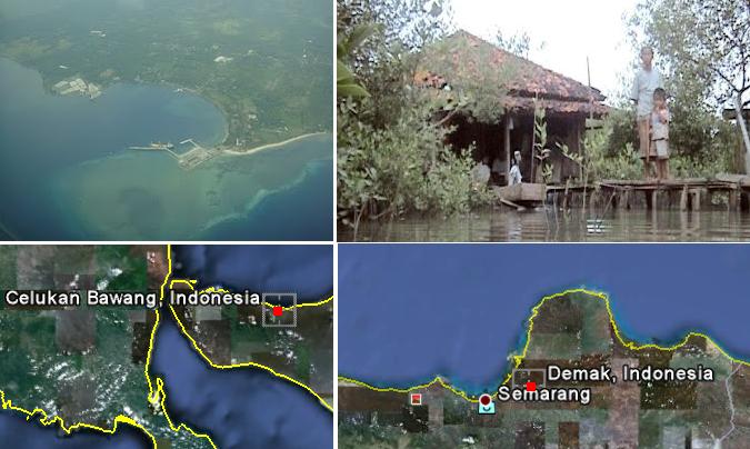
- Celukan Bawang Bali,More flooding
March 6, 2011
http://celukan-bawang.blogspot.com/2011/03/banjir-melanda-lagi-6-maret-2011.html
- Floods hit the village again Celukan Bawang Bali, rain intensity is high enough this region led to the village is
often hit by flooding, here are the photos of the state when the flood started to come. Things like this only in
temo less than 1 hour, the velocity of water moving about 20km/jam with water discharge that continues to
rise, access to the port disrupted traffic and access roads, too choked up due to this flood
-
- Drowning Demak
March 9, 2011
http://news.okezone.com/read/2011/03/09/340/432921/abrasi-30-tahun-lagi-demak-tenggelam
- Environmental damage in coastal North Coast of Java Sea the more alarming. The main cause is abrasion or
erosion of land by the sea waves. Even the two villages, namely Senik and Tambaksari in Demak, Central
Java, missing and erased from the map of Indonesia.
Per the Zetas, though the sinking of the plate tongue holding Indonesia has been slowed due to plate undulation, which set in
promptly at the start of the process, it is still continuing apace. A new date can be estimated.
ZetaTalk Statement 3/5/2011: When plate undulation started promptly after the plate tongue holding Indonesia
started to sink, we informed the public. On December 31, 2010 in fact, before the year's end. Prior to that, we had
stated the sinking would take 2-3 weeks. It is now at 10 weeks, and counting. Plate undulation is not something that
stops, once it starts, as momentum is involved. Sinking only commences, again, when the curve of the
Indo-Australian Plate under Sumatra and Java lifts, which is only part of the undulation process, a minority of the
time. This can be computed if one looks over the documentation Nancy has provided on buoy readings. Where the
lift lasts for a days or two at most, the period of time when the curve is pressed down again lasts for a week. Thus,
sinking could be assumed to be in process only 1/5 of the time, 2-3 weeks thus taking 10-15 weeks, and this pace
assuming no other interference with the sinking process is involved.
You received this Newsletter because you subscribed to the ZetaTalk Newsletter service. If undesired, you can quickly Unsubscribe.
|