7 of 10
Domino
The Zetas have described the Indo-Australian Plate as the brake
point. When it lifts on its eastern edge, and plunges under the
Himayalas on the northern edge, a domino effect occurs on all
the other Earth plates. Generally this moves from West to East,
round the globe.
ZetaTalk Explanation
12/21/2007: What
does this increasingly violent daily lurch do to the Earth's
plates, which have loosened up and become more fluid lately
due to being subjected to the constant jerking of the wobble?
Great quakes that affect the globe in its entirety must first
occur at one of the brake points in the global mesh of plates.
For the Earth, this is primarily the point where the
Indo-Australian plate dives under the Himalayas. The
Himalayas, the highest mountains in the world, show how often
this brake point has been hammered in the past. When this
brake point moves, it allows the many compression points in
the great Pacific to move. This includes rolling the top
portion of S America westward. This also includes allowing the
N American continent to move westward, but as this continent
is locked at the top border with Russia, this movement
manifests as a diagonal rip, the New Madrid fault line
adjustment we have predicted. Elsewhere around the world such
a strong adjustment creates an opening in the Indian Ocean,
which allows Africa to roll toward the void, opening the
African Rift further. This also puts pressure on the Arabian
Plate, so that it rolls in place, a move which affects all the
many fault lines that run through this region. A major
adjustment of this type unleashes a series of great quakes,
which then subside, as the Earth plates lock into new brake
points and hold.
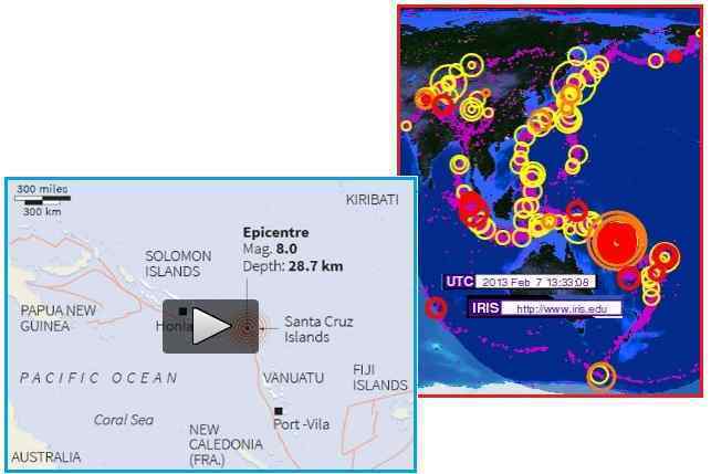
This can be seen in what has unfolded since 2013 arrived. The
magnitude 8.0
quake on February 6, 2013 at the Santa Cruz islands has
been breathtaking in the hammering that has followed. There were
118 quakes between magnitude 4.7 and 7.1 within 48 hours, and
this pace continued for days. Per the Zetas, fluid and more
frequent and intense quakes can be expected as the pace will
only increase.
- Solomon Islands Earthquake Triggers
Tsunami
February 6, 2013
http://www.guardian.co.uk/world/2013/feb/06/solomon-islands-earthquake
- A powerful earthquake off the
Solomon Islands generated a tsunami up to 1.5 metres (5ft)
high that damaged dozens of homes and left several people
missing, presumed dead. More than 50 people were killed
and thousands lost their homes in April 2007 when a
magnitude-8.1 quake hit the western Solomon Islands,
sending waves crashing into coastal villages.
ZetaTalk Warning
2/9/2013: We
mentioned that some parts of the globe, along some plate
borders, would endure continuous movement during the 8 of 10.
Of course this would invariably include the lifting edge of
the Indo-Australian Plate, as this is the brake point. What
goes on when a region is under continuous movement? Rock
fingers break, allowing movement along the plate border, but
then other rock fingers catch. The pressure to move again
builds up almost immediately. As we mentioned some time ago,
rock fingers along plate edges have smoothed, broken off,
allowing more fluid motion. The 7 of 10 plate movements are a
dance that encourages the pace and violence of plate movements
to accelerate. A compressed Pacific is certainly encouraging a
yaw in the Atlantic. Each plate movement tears off more rock
fingers, along the entire plate edge, so that future plate
movement is facilitated. Then the next plate shift is bigger,
broader, and encourages a larger domino effect to follow.
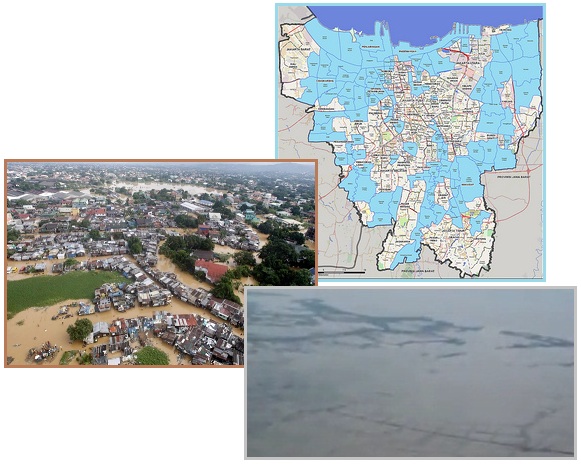
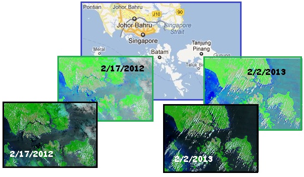
The month before, during January, 2013, renewed sinking on the
Sunda Plate was evident in reports
from Jakarta and Singapore. Jakarta reports that 50% of
the city has an elevation lower than sea level, an astonishing
admission after months of denial and attempts to pump out the
city and create barriers. Experts from the Netherlands had been
called in. Flooding in Singapore now occurs more quickly in low
lying areas, but the final sinking for Singapore has not yet
occurred. There has been scant progress during the past year,
when the Council of Worlds has modulated the plate movements
while the cover-up broke, as can be seen from MODIS satellite
images. Wikipedia found it important to report on flooding in
Singapore only since June, 2010, when the Sunda Plate began to
sink. Apparently, Singapore did not experience rain prior to
this time.
- Heavy Flooding Kills 15 in Indonesia
January 18, 2013
http://www.presstv.ir/detail/2013/01/18/284162/6-die-in-indonesia-flooding/
- About 50 percent of Jakarta is
under water, ranging from 25 centimeters to 4 meters.
- Stay Alert on Floods
January 26, 2013
http://www.thejakartapost.com/news/2013/01/26/stay-alert-floods-jokowi
- Around 24,000 hectares or 40
percent of Jakarta’s land mass is lower than sea level.
- As Floods Cripple Jakarta, President
Calls for Public Safety First
January 17, 2013
http://www.antaranews.com/en/news/86919/as-floods-cripple-jakarta
- The five-year-cycle floods have
been predicted to hit Jakarta early this year, but some
people said that this time was worse than the floods in
2007 that had submerged Jakarta and suburban areas and
claimed more than 80 lives.
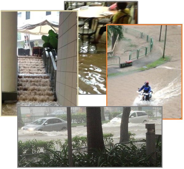
- 2010-2012 Singapore floods
http://en.wikipedia.org/wiki/2010-2012_Singapore_floods
- The 2010–2012 Singapore floods
refers to the series of flash floods that hit various
parts of the city state Singapore in 2010, 2011 and 2012.
The floods came about due to the higher-than-average
rainfall that aggregated over a short period of time.
True to expectations, The February 6 quake in Santa Cruz was
followed within days by a significant magnitude 7.0
quake in Colombia. Within a day there were quakes all up
and down the spine of the Andres, along the Atlantic Rift where
the edge of the S American Plate lies, and in Panama where the
Caribbean and S America plates join. The domino effect can
clearly be seen.
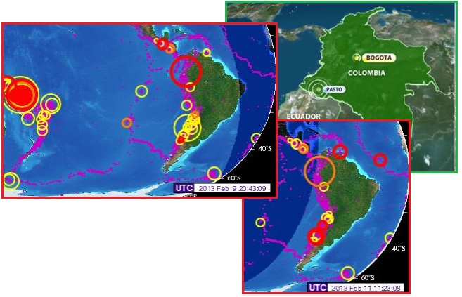
- 7.0 Earthquake Rocks Colombia
February 9, 2013
http://www.usatoday.com/story/news/world/2013/02/09/earthquake-colombia/
- The quake was felt in the
Colombian capital of Bogota, some 340 miles (545
kilometers) to the northeast, and across much of
neighboring Ecuador.
Trinidad Shelf
Signs of sinking tension in the Caribbean can be seen north of
Venezuela, where a shelf off-shore from Trinidad has developed.
Per the Zetas, Trinidad is to be ripped apart, the northern half
sinking almost entirely, but at first the plate resist ripping
and cling to each other.
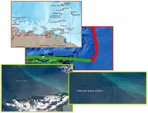
- Weird Underwater Waves Spotted from
Space
February 5, 2013
http://news.yahoo.com/weird-underwater-waves-spotted-space-211812642.html
- This photograph, taken on Jan. 18
by a crewmember on the International Space Station, shows
internal waves north of the Caribbean island of Trinidad,
as featured by NASA's Earth Observatory.
- Image of the Day
January 18, 2013
http://earthobservatory.nasa.gov/IOTD/view.php?id=80337
- All the internal waves are
probably caused by the shelf break near Tobago (outside
the image to top right). The shelf break is the step
between shallow seas (around continents and islands) and
the deep ocean. It is the line at which tides usually
start to generate internal waves.
ZetaTalk Explanation
2/9/2013: Prior
to the plates doing any serious movement, they resist moving,
clinging along their edges to the other, holding to the status
quo. But the scripted drama reveals itself. The S American
roll pushes the hump of the S American Plate over the
Caribbean Plate, and in the process pushing the Caribbean
Plate down. This will tear Trinidad apart, but prior to
this trauma, sinking in those areas with a thin plate, deep
under the sea, will drop. The shelf drop north of Trinidad is
not as steep as the recent ISS photo shows. The shelf drop
occurs well past Tobago. Both Trinidad and Tobago are on
the shelf, but when the Caribbean Plate sinks this will
change. Tobago is destined to sink, but the crust is
thick there, as is the crust under Trinidad. Thus the islands
have not reported sinking as yet, still clinging to the status
quo, but the undersea wave patterns show that a new shelf is
developing, close to where the rip across Trinidad will occur.
Great Lakes Drought
Are the Great Lakes losing their water? This is the report for
Lake Michigan and Lake Huron, which have record low water
levels.
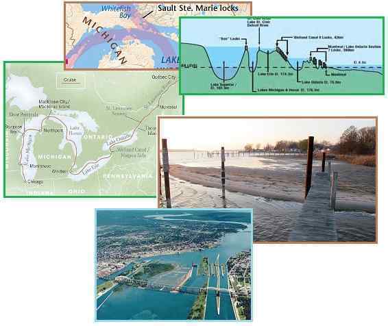
- Lake Michigan Hits Record Low Level
February 8, 2013
http://phys.org/news/2013-02-lake-michigan.html#jCp
- The water level is tracked by
gauges placed around Lakes Michigan and Huron, which are
actually one body of water connected by the Straits of
Mackinac. Water levels on the Great Lakes fluctuate
seasonally by inches and by as much as several feet over a
period of years, depending on long-term weather patterns.
But they were previously bracketed by the record low of
March 1964 and the record high of October 1986. Now the
lakes are headed into uncharted territory, and some want
the U.S. and Canadian governments to do something about
it.
- 2 Great Lakes Hit Lowest Water Level
on Record
February 6, 2013
http://news.yahoo.com/2-great-lakes-hit-lowest-water-level-record
- Measurements taken last month show
Lake Huron and Lake Michigan have reached their lowest ebb
since record keeping began in 1918. The other Great Lakes
— Superior, Erie and Ontario — were also well below
average.
- Great Lakes Waterway
http://en.wikipedia.org/wiki/Great_Lakes_Waterway
- The Great Lakes Waterway is a
system of channels and canals that makes all of the Great
Lakes accessible to oceangoing vessels. Its principal
civil engineering components are the Well and Canal,
bypassing Niagara Falls between Lake Ontario and Lake
Erie, and the Soo Locks, bypassing the rapids of the St.
Mary’s River between Lake Superior and Lake Huron, at
Sault Sainte Marie.
Per the Zetas there is no loss of water but deforming of the
lake bottoms due to the bowing pressure on the N American Plate.
ZetaTalk Clarity
2/16/2013: Michigan
and Huron are low, but the Great Lakes above and to the East
of them are not so afflicted. Since the lakes are connected,
and share their water, why would this be? The speed that water
will MOVE between the lakes is determined in part by water
pressure. High water in Lake Superior and low water below in
Michigan and Huron would cause the flow to speed up down the
St. Mary’s River, thus equalizing these lakes. Likewise, a low
water pressure due to low height in Lake Huron would cause the
flow past Detroit into Lake Erie to slow. Something else has
caused the discrepancy. The Seaway is ripping open, and as we
have explained this affects land all the way to the Black
Hills of N Dakota. We have stated that the Pole Shift
will rip the Seaway further at Duluth at the end of Lake
Superior. Then why are the lower Great Lakes the first to show
changes?
The N American continent is
being pulled into a bow, which due to the rock strata will
slip diagonally along the New Madrid Fault Line. During the
Pole Shift the Seaway split will progress more directly coast
to coast. The pending New Madrid trauma can already be seen in
the crevasse in the Michigan Peninsula above Wisconsin, and
the constant hum in Roseville near Detroit and Lake St.
Clair. This is the weak spot, at present. Why
would this cause the water level in Lake Huron and Lake
Michigan to drop? This is an illusion. The lake bottoms are
deforming, rising up under the tension as the rock strata is
pulled taught. This gives the impression that the water depth
is less. Deforming also causes the slope from coastlines to
lift, so more of the lake bottom is revealed, which also gives
the illusion that the water level had dropped. After the
New Madrid adjustment this weakness will be dispelled.
The Zetas have given extensive predictions on the Seaway and the
fate of the Great Lakes,
located in the Safe Locations section. The Pole Shift itself
will rip the Seaway open all the way to Duluth and on to the
Black Hills of S Dakota. But prior to the time of the Pole
Shift New Madrid ripping will occur further south of
Duluth. This is clearly setting up to happen, as one can
see from the deforming lake bottoms.
8 of 10 Overlap
The 7 of 10 sequence was
introduced by the Zetas in October, 2010 and began that same
year before the end of December. But the rapid execution of the
sequence was delayed and mitigated,
though it has emerged as predicted. The Council of Worlds
intervened, wanting the people of Planet Earth to be aware of
the pending passage, so the opportunity for spiritual lessons
would not be lost before death ended the incarnation. Thus the
Council of Worlds went to war on the
cover-up, and Obama moved forward with plans to inform the
peoples of the world that President Reagan’s 1983 Executive
Order imposing the cover-up on National Security grounds was
reversed. Meanwhile, by delaying and mitigating the 7 of 10
plate movements, this phase began to overlap into the 8 of 10
changes. Just how does that work?
The Zetas explained that the 8 of 10 would result in greater
visibility of the Planet X complex. How does this differ
from what we have today, where the Moon Swirls and a dramatic
Second Sun are often seen, naked eye and without filters?
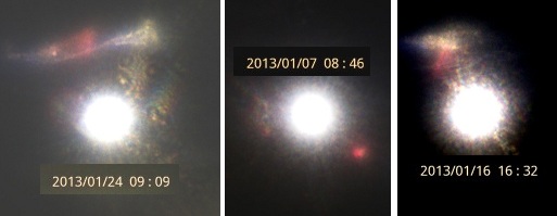
ZetaTalk Comparison
2/2/2013: We
have described an increased visibility of Planet X, aka Nibiru
and its components during the 8 of 10. But has this not
already arrived to some degree? One can scarcely go on YouTube
without being flooded by videos of Nibiru, aka Planet X and
its Moon Swirls. For the 8 of 10, as it progresses, Planet X
will be positioned more to the right in the line of sight, so
that sunlight will bounce off the dust cloud clinging to and
thus shrouding Planet X, supporting dramatic Second Sun
sightings on a daily basis, worldwide.
The Zetas explained that the 8 of 10 would include a more
severe wobble, with a blending
of the seasons. Many would argue that we already have
this, with increased storms, sunrise or sunset often out of
place, and weather swings.
ZetaTalk Comparison
2/2/2013: During
the 8 of 10, the Earth wobble will become so extreme, on a
daily basis, that none can deny it. The wobble has already
reached the point where it has pushed the weather into drought
and deluge, severe storms and high winds, and temperature
swings. The Global Warming excuse has failed to cover this,
and the populace seeks an answer which only an admission on
the near presence of Planet X can provide. But the wobble has
not yet reached the point it will during the 8 of 10, when the
Sun will be so out of place that none can deny it. Nor has a
continuous blending of the seasons occurred as yet, though
such blending is already occurring briefly and sporadically on
occasion.
The Zetas stated that the 8 of 10 would include clashes with Venus and the Dark Twin, which
would loom close and be more visible. But don’t we have this
already? The images of a Monster Dark Twin or a Monster Venus
are already being captured on film.
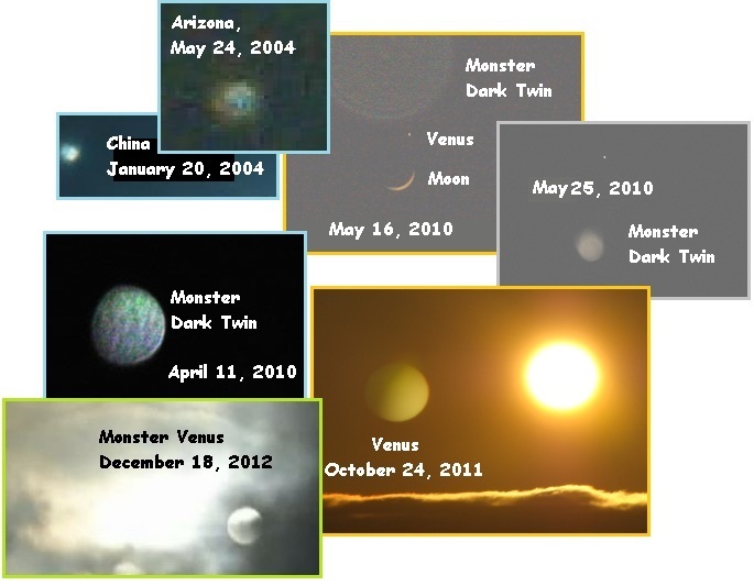
ZetaTalk Comparison
2/2/2013: We
stated that during the Last Weeks, Venus and the Dark Twin
would escape the cup, allowing Planet X and the Earth to
engage in their final wrestling moves. But what will occur
prior to this point? Already Venus and the Dark Twin loom
close on occasion, appearing as the monster persona with
ballooning light rays and puzzling those who see this. These
instances will increase, added to the certainly that Planet X,
aka Nibiru, is indeed nearby. NASA will throw a frantic public
onto Nancy and ourselves to explain the Repulsion Force when
their explanations on planetary body motions fail. How do they
know that Venus and the Dark Twin won’t crash into the Earth?
Because the Zetas say so, will be their implicit answer.
The Zetas hinted that the 8 of 10 would include plate movements
beyond the 7 of 10 predictions, including continuous
movement in some places, continental
drift, and explosions in
Iraq. But how much worse can it get? Aren’t we already
into the 7 of 10 scenarios? The S American roll has been in
process for some time.

ZetaTalk Comparison
2/2/2013: Where
we are currently waiting for the 7 of 10 plate movements to
complete, the stress on the plates is apparent. The sinking of
the Sunda Plate and the folding of the Philippine and Mariana
plates is approximately 70% complete, but the final moves will
occur in conjunction with further progress on the S American
roll. Though the cover-up has found it necessary to kill
almost all the buoys on the Nazca and Cocos plates, the S
American roll has barely begun, perhaps 13% of the overall
changes expected. And the African roll is barely twitching, at
present, perhaps 5% into the process. The chaos that has
already been experienced is thus only a hint of what is to
come. The N American continent is under tension so great that
the Salt Dome caverns along the Gulf are fracturing, but the
changes here likewise have not truly started.
We stated that those aspects
of the 7 of 10 that would result from rapid plate movements –
specifically the European tsunami – would be mitigated to
occur more slowly. The European tsunami is a factor of a rip
in the North Atlantic Rift, and when occurring slowly would
result in less water rebounding, and a smaller tsunami height
as a consequence. If these 7 of 10 plate movements are
devastating, what will occur after these have completed,
during the 8 of 10? We have at most hinted at what will occur.
Continuous plate movement in some areas will occur, along with
a changed relationship of the continents to one another.
The predicted explosions in Iraq as the oil fields are
ruptured will also only occur during the 8 of 10 phase.
Certainly clear signs in the skies, an Earth wobble that leaves
no doubt that Nibiru has a grip on the Earth, and almost
continuous plate movement will leave few doubting the Zeta
description of the coming Pole Shift. Even those who are
unaware of the ZetaTalk message will be frantic from the food
shortages or the floods and earthquake damage. They will be on
the move, looking for a better place, a situation the Zetas
predicted from the start. If the 8 of 10 is anything, it is a
phase driven by sociological change.
ZetaTalk Comparison
2/2/2013: But
the major 8 of 10 scenarios will be sociological, with riots
and rebellion on the increase as food shortages increase and
people realize the impact the Pole Shift will have on their
lives. Families will be ripped apart by argument as those in
denial refuse to budge and those determined to survive set
their plans. Migration of desperate peoples affecting every
country in some way will occur in the extreme, dominating the
UN agenda and slamming borders shut. There is room on the
planet to shelter all, though most may starve eventually due
to food shortages. All this is the spiritual opportunity
provided by the time of the passage, on Planet Earth.
|